


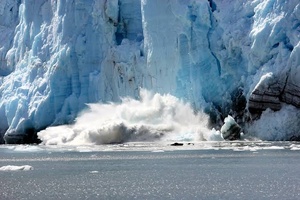
The catastrophic flash flood in Nepal's Rasuwa district has brought a growing Himalayan danger into sharp focus: a glacier can become a source of sudden destruction long before it disappears. Preliminary satellite analysis indicates that a substantial section of a glacier collapsed from an elevation of about 5,200 metres and plunged roughly 1,200 metres into the valley below. The resulting ice, rock and sediment surge overwhelmed the Lhende River system and sent a powerful flood downstream, destroying infrastructure and leaving hundreds dead or missing.
The precise chain of events is still being investigated, and scientists have cautioned against assigning the disaster to a single cause. An initial report of an earthquake was later revised after geological analysis indicated that the seismic signal was generated by the collapse itself. Rapid snow and ice melting appears to have occurred shortly before the event, while the possible contribution of warming, unstable slopes and human construction remains under investigation. That uncertainty is important because glacier-related disasters rarely have one simple trigger. They often emerge from a combination of warming, ice loss, unstable mountain terrain, intense rainfall and development in exposed valleys.
Nepal's disaster is therefore significant beyond its immediate death toll. It provides a case study of how climate change is altering the physical conditions of the Himalayas, turning glaciers from relatively slow-moving stores of freshwater into increasingly unstable components of a complex mountain hazard system. The immediate challenge is responding to individual disasters, but the larger problem is identifying where similar failures could occur before they happen.
Warming Is Reshaping the Himalayan Hazard System
The strongest evidence for a changing Himalayan environment comes from the long-term loss of ice. The United Nations reported in 2023 that Nepal had lost almost one-third of its ice in slightly more than three decades and that glacier melting during the previous decade was 65 percent faster than during the decade before it. The significance of those figures extends beyond the shrinking glaciers themselves. As ice retreats, new meltwater pools and glacial lakes can develop, while the slopes and rock structures previously supported by frozen ground can become less stable.
Recent scientific research supports the broader connection between rising temperatures and changing mountain flood risks, while also showing why the relationship should not be oversimplified. A 2025 analysis of more than 1,000 floods across High Mountain Asia found that flood frequency has increased since 2000 and that floods are becoming less predictable in their timing. The researchers identified temperature rise as a key driver of the changing pattern. This does not mean every Himalayan flood is caused by climate change, but it indicates that warming is altering the background conditions under which individual hazards develop.
Glaciers are particularly important because their retreat can produce several hazards at once. As ice melts, water can accumulate behind natural dams made of loose rock and sediment. These lakes can grow until an avalanche, landslide, intense rainfall event or structural failure causes them to release their contents suddenly. The resulting glacial lake outburst flood can carry enormous quantities of water, mud, rocks and debris through narrow valleys.
A 2025 study of the Everest region found that small glacial lakes have been expanding and that their growth has shown unusually strong increases in recent years. Another global study published in 2025 identified a marked increase in reported glacial lake outburst floods after the 1980s, with the long-term pattern closely associated with changes in global air temperature. The research also highlights a time lag: warming can destabilise glaciers and expand lakes gradually, while the eventual disaster may occur years later.
Glacial Bursts Are Becoming More Complex
The Nepal disaster demonstrates why the term "glacial flood" can be misleading if it suggests a simple release of meltwater. The preliminary evidence points instead to a cascading event involving ice, rock, sediment and water. A collapsing glacier can strike the valley floor with enormous force, displace material, obstruct a river and then release a sudden surge downstream. The resulting flood can therefore be far more destructive than the volume of melting ice alone would suggest.
The 2024 flood in Nepal's Thame Valley illustrates the same principle. An investigation by the International Centre for Integrated Mountain Development found that a rock avalanche struck a glacial lake at about 4,900 metres, creating a displacement wave that caused the lake to breach and release an estimated 156,000 cubic metres of water. The study described the disaster as a complex chain reaction involving several geological and environmental processes rather than a single trigger.
This complexity is becoming increasingly important as the Himalayan environment warms. A glacier may retreat because of sustained temperature increases, while a sudden flood may require a completely different immediate trigger. Heavy rainfall, an avalanche, a landslide, permafrost degradation or a sudden structural failure can provide that final trigger. Climate change can therefore increase vulnerability without determining the exact date or mechanism of an individual disaster.
That distinction matters for disaster policy. It is scientifically difficult to say that warming directly caused a particular glacier collapse without detailed observations of the glacier, weather conditions, geology and hydrology before the event. But it is equally misleading to examine each disaster in isolation when long-term evidence shows that warming is changing glaciers, lakes and mountain slopes across the region.
Infrastructure Is Increasing the Potential Damage
The physical hazard is only one part of the problem. The consequences become dramatically worse when roads, bridges, hydropower plants, settlements and tourist routes occupy narrow valleys below unstable mountain terrain. The Rasuwa disaster affected an area containing important transport and energy infrastructure, while the flood sent water and debris through river systems that connect high-altitude valleys with much more populated areas downstream.
This creates a difficult development problem for Nepal and other Himalayan countries. Mountain valleys are among the few places where roads, settlements and power infrastructure can realistically be built, yet those same valleys naturally concentrate floodwater and debris. Hydropower is especially exposed because projects require rivers and steep terrain, precisely the features that can amplify glacier-related disasters.
Research from the eastern Himalayas has already identified this interaction. A 2024 assessment of glacial lake outburst risk in Sikkim mapped hundreds of glacial lakes and found multiple levels of susceptibility among moraine-dammed lakes. The study concluded that climate-driven ice loss combined with expanding infrastructure could increase the consequences of future disasters.
The lesson is not that Himalayan infrastructure development should stop. It is that conventional assessments based mainly on historical flood patterns may no longer be sufficient. A road or power project designed around the assumption that yesterday's climate represents tomorrow's risk could underestimate hazards created by changing glaciers and mountain slopes.
Early Warning Must Move Beyond Weather Forecasts
The Nepal disaster also highlights a major weakness in conventional disaster preparedness. Weather monitoring alone cannot reliably detect every glacier collapse, because the decisive event can occur at high altitude with little warning. Effective protection requires continuous observation of glaciers, lakes, slopes, river levels and other indicators that can reveal instability before a catastrophic release reaches populated valleys.
Satellite monitoring is becoming increasingly valuable because it can identify changes in glacier geometry and lake size across remote terrain where permanent ground stations are difficult to maintain. But satellites need to be combined with ground-based sensors, automated river gauges, seismic monitoring and communications systems capable of reaching communities rapidly. The International Centre for Integrated Mountain Development has repeatedly stressed the need for stronger monitoring and early warning across the Hindu Kush Himalayas as glacier-related hazards become more complex.
The challenge is especially urgent because the region contains thousands of glacial lakes and supports hundreds of millions of people directly or indirectly through mountain water systems. A 2026 review of the Himalaya and Karakoram found that continued glacier retreat is contributing to the formation and expansion of glacial lakes and increasing concern over glacial lake outburst floods. The same research emphasises that risk reduction requires systematic monitoring, hazard mapping and stronger preparedness rather than waiting for disasters to reveal which locations are dangerous.
Nepal's latest catastrophe should therefore be treated neither as proof that every glacier collapse is directly caused by global warming nor as an isolated natural accident. The evidence points to a more complicated and consequential reality. A warming climate is changing the glaciers and mountain systems that determine where water accumulates, how slopes behave and how rapidly hazards can develop. Individual disasters still require specific triggers, but the environment in which those triggers operate is changing.
That is what makes the Nepal case important. The greatest Himalayan threat may not come from the gradual disappearance of glaciers alone, but from the unstable transition that occurs while they are shrinking. As ice retreats, lakes expand, slopes weaken and infrastructure spreads deeper into mountain valleys, the potential for cascading disasters grows. The challenge for governments is no longer simply to predict floods. It is to understand a rapidly changing mountain system well enough to identify where the next collapse could begin, how quickly its effects could travel downstream and whether communities will receive enough warning to escape.
(Source:www.marketscreener.com)
The precise chain of events is still being investigated, and scientists have cautioned against assigning the disaster to a single cause. An initial report of an earthquake was later revised after geological analysis indicated that the seismic signal was generated by the collapse itself. Rapid snow and ice melting appears to have occurred shortly before the event, while the possible contribution of warming, unstable slopes and human construction remains under investigation. That uncertainty is important because glacier-related disasters rarely have one simple trigger. They often emerge from a combination of warming, ice loss, unstable mountain terrain, intense rainfall and development in exposed valleys.
Nepal's disaster is therefore significant beyond its immediate death toll. It provides a case study of how climate change is altering the physical conditions of the Himalayas, turning glaciers from relatively slow-moving stores of freshwater into increasingly unstable components of a complex mountain hazard system. The immediate challenge is responding to individual disasters, but the larger problem is identifying where similar failures could occur before they happen.
Warming Is Reshaping the Himalayan Hazard System
The strongest evidence for a changing Himalayan environment comes from the long-term loss of ice. The United Nations reported in 2023 that Nepal had lost almost one-third of its ice in slightly more than three decades and that glacier melting during the previous decade was 65 percent faster than during the decade before it. The significance of those figures extends beyond the shrinking glaciers themselves. As ice retreats, new meltwater pools and glacial lakes can develop, while the slopes and rock structures previously supported by frozen ground can become less stable.
Recent scientific research supports the broader connection between rising temperatures and changing mountain flood risks, while also showing why the relationship should not be oversimplified. A 2025 analysis of more than 1,000 floods across High Mountain Asia found that flood frequency has increased since 2000 and that floods are becoming less predictable in their timing. The researchers identified temperature rise as a key driver of the changing pattern. This does not mean every Himalayan flood is caused by climate change, but it indicates that warming is altering the background conditions under which individual hazards develop.
Glaciers are particularly important because their retreat can produce several hazards at once. As ice melts, water can accumulate behind natural dams made of loose rock and sediment. These lakes can grow until an avalanche, landslide, intense rainfall event or structural failure causes them to release their contents suddenly. The resulting glacial lake outburst flood can carry enormous quantities of water, mud, rocks and debris through narrow valleys.
A 2025 study of the Everest region found that small glacial lakes have been expanding and that their growth has shown unusually strong increases in recent years. Another global study published in 2025 identified a marked increase in reported glacial lake outburst floods after the 1980s, with the long-term pattern closely associated with changes in global air temperature. The research also highlights a time lag: warming can destabilise glaciers and expand lakes gradually, while the eventual disaster may occur years later.
Glacial Bursts Are Becoming More Complex
The Nepal disaster demonstrates why the term "glacial flood" can be misleading if it suggests a simple release of meltwater. The preliminary evidence points instead to a cascading event involving ice, rock, sediment and water. A collapsing glacier can strike the valley floor with enormous force, displace material, obstruct a river and then release a sudden surge downstream. The resulting flood can therefore be far more destructive than the volume of melting ice alone would suggest.
The 2024 flood in Nepal's Thame Valley illustrates the same principle. An investigation by the International Centre for Integrated Mountain Development found that a rock avalanche struck a glacial lake at about 4,900 metres, creating a displacement wave that caused the lake to breach and release an estimated 156,000 cubic metres of water. The study described the disaster as a complex chain reaction involving several geological and environmental processes rather than a single trigger.
This complexity is becoming increasingly important as the Himalayan environment warms. A glacier may retreat because of sustained temperature increases, while a sudden flood may require a completely different immediate trigger. Heavy rainfall, an avalanche, a landslide, permafrost degradation or a sudden structural failure can provide that final trigger. Climate change can therefore increase vulnerability without determining the exact date or mechanism of an individual disaster.
That distinction matters for disaster policy. It is scientifically difficult to say that warming directly caused a particular glacier collapse without detailed observations of the glacier, weather conditions, geology and hydrology before the event. But it is equally misleading to examine each disaster in isolation when long-term evidence shows that warming is changing glaciers, lakes and mountain slopes across the region.
Infrastructure Is Increasing the Potential Damage
The physical hazard is only one part of the problem. The consequences become dramatically worse when roads, bridges, hydropower plants, settlements and tourist routes occupy narrow valleys below unstable mountain terrain. The Rasuwa disaster affected an area containing important transport and energy infrastructure, while the flood sent water and debris through river systems that connect high-altitude valleys with much more populated areas downstream.
This creates a difficult development problem for Nepal and other Himalayan countries. Mountain valleys are among the few places where roads, settlements and power infrastructure can realistically be built, yet those same valleys naturally concentrate floodwater and debris. Hydropower is especially exposed because projects require rivers and steep terrain, precisely the features that can amplify glacier-related disasters.
Research from the eastern Himalayas has already identified this interaction. A 2024 assessment of glacial lake outburst risk in Sikkim mapped hundreds of glacial lakes and found multiple levels of susceptibility among moraine-dammed lakes. The study concluded that climate-driven ice loss combined with expanding infrastructure could increase the consequences of future disasters.
The lesson is not that Himalayan infrastructure development should stop. It is that conventional assessments based mainly on historical flood patterns may no longer be sufficient. A road or power project designed around the assumption that yesterday's climate represents tomorrow's risk could underestimate hazards created by changing glaciers and mountain slopes.
Early Warning Must Move Beyond Weather Forecasts
The Nepal disaster also highlights a major weakness in conventional disaster preparedness. Weather monitoring alone cannot reliably detect every glacier collapse, because the decisive event can occur at high altitude with little warning. Effective protection requires continuous observation of glaciers, lakes, slopes, river levels and other indicators that can reveal instability before a catastrophic release reaches populated valleys.
Satellite monitoring is becoming increasingly valuable because it can identify changes in glacier geometry and lake size across remote terrain where permanent ground stations are difficult to maintain. But satellites need to be combined with ground-based sensors, automated river gauges, seismic monitoring and communications systems capable of reaching communities rapidly. The International Centre for Integrated Mountain Development has repeatedly stressed the need for stronger monitoring and early warning across the Hindu Kush Himalayas as glacier-related hazards become more complex.
The challenge is especially urgent because the region contains thousands of glacial lakes and supports hundreds of millions of people directly or indirectly through mountain water systems. A 2026 review of the Himalaya and Karakoram found that continued glacier retreat is contributing to the formation and expansion of glacial lakes and increasing concern over glacial lake outburst floods. The same research emphasises that risk reduction requires systematic monitoring, hazard mapping and stronger preparedness rather than waiting for disasters to reveal which locations are dangerous.
Nepal's latest catastrophe should therefore be treated neither as proof that every glacier collapse is directly caused by global warming nor as an isolated natural accident. The evidence points to a more complicated and consequential reality. A warming climate is changing the glaciers and mountain systems that determine where water accumulates, how slopes behave and how rapidly hazards can develop. Individual disasters still require specific triggers, but the environment in which those triggers operate is changing.
That is what makes the Nepal case important. The greatest Himalayan threat may not come from the gradual disappearance of glaciers alone, but from the unstable transition that occurs while they are shrinking. As ice retreats, lakes expand, slopes weaken and infrastructure spreads deeper into mountain valleys, the potential for cascading disasters grows. The challenge for governments is no longer simply to predict floods. It is to understand a rapidly changing mountain system well enough to identify where the next collapse could begin, how quickly its effects could travel downstream and whether communities will receive enough warning to escape.
(Source:www.marketscreener.com)
